Ships from Manufacturer Typically Within 2-4 Weeks - Lead Times Vary
Quickship Only Available for the following Options:
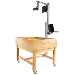
The Augmented Reality Sandbox creates a more interactive and engaging sandbox experience, inspiring STEM and STEAM learning. Developed by UC Davis W.M Keck Center for Active Visualization in Earth Sciences, supported by the National Science Foundation.
This interactive sandbox uses 3D visualization to combine the sandbox experience with virtual topography and water for a more engaging play experience. This high-tech educational play solution allows users to create topography models by shaping real sand, which is then augmented in real-time by an elevation color map, topographic contour lines, and simulated water. The system teaches students how to read a topography map, the meaning of contour lines, watersheds, catchment areas, levees, and much more. Renders use a closed loop of a Microsoft Kinect 3D camera, powerful simulation and visualization software, and a data projector. The software was designed by a team of scientists at UC-Davis. A wire management system keeps the cords from interfering with the box. Shelf to hold the laptop while in use, which folds away with a collapsible hinge. The 36-inch dimension measures to the top of the table. Sand not included. We recommend six orders of item 1601030 for 300 pounds of sand.
Features
Designed with solid oak, oak plywood and moves on heavy duty locking casters
Inspires STEM and STEAM learning through augmented reality right in the classroom
Streamline setup includes detailed instructions for calibrating the software and running the program are included
Features everything you need for creating the highest quality geography lesson